Very Hot Weather Warning remains in force as extreme heat persists in Hong Kong
Very Hot Weather Warning remains in force as extreme heat persists in Hong Kong
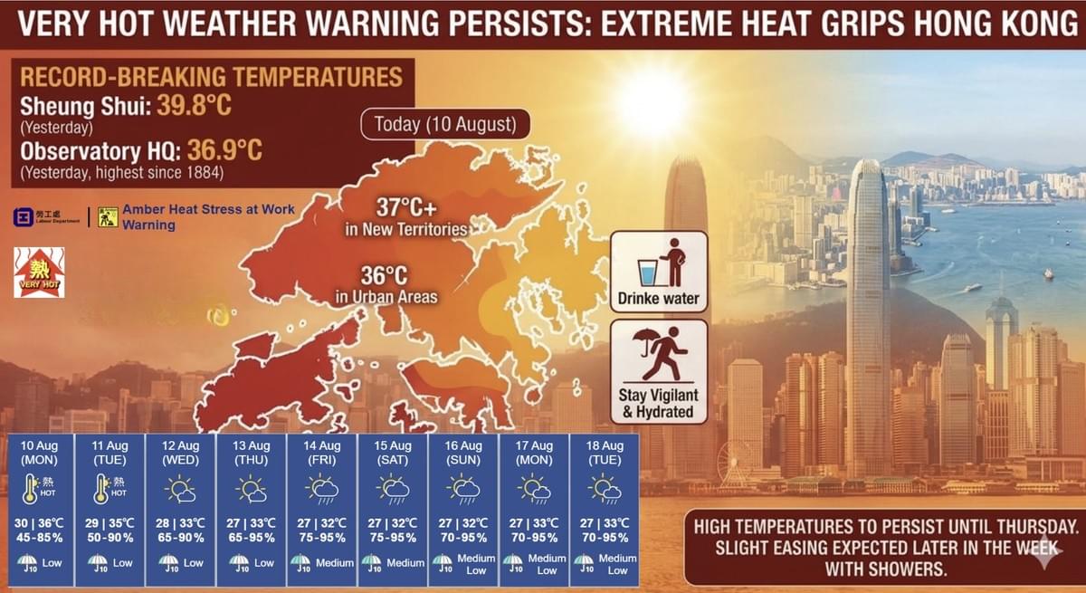
The Very Hot Weather Warning is still in effect across Hong Kong. The Labour Department issued a Yellow Working Heat Stress Warning this morning (10 August).
The Hong Kong Observatory forecasts mainly fine weather today, with extremely hot conditions during the day. Maximum temperatures are expected to reach about 36°C in urban areas and one to two degrees higher in the New Territories. Winds will be moderate from the west to northwest, becoming fresh on high ground initially.
Looking ahead, tomorrow (11 August) will remain extremely hot, with high temperatures continuing for the following one to two days.
In a Special Weather Tip issued at 4:50 a.m., the Observatory noted that Tropical Cyclone Dolphin is moving across eastern China and inland. Its outer subsiding airflow will continue to bring extremely hot weather to Hong Kong today and tomorrow, with temperatures in some areas reaching 37°C or above.
Members of the public are advised to monitor their health, drink plenty of water, and take adequate heat precautions. Vigorous outdoor exercise should be avoided. Anyone experiencing symptoms such as dizziness, headache, nausea, shortness of breath or confusion should rest immediately, seek help and obtain medical attention as soon as possible.
Yesterday, Sheung Shui recorded 39.8°C — the highest temperature logged in Hong Kong since the Observatory began installing automatic weather stations in the 1980s. High temperatures are expected to persist until at least Thursday.
The Observatory’s Special Weather Tip also stated that hot weather will continue on Wednesday (12 August) and Thursday (13 August). Under the influence of upper-air disturbances later in the week, showers are expected over southern China, bringing a slight easing of the high temperatures.
A southwesterly airstream is forecast to affect the Guangdong coast around mid-week, maintaining high temperatures in the region along with a few showers. Upper-air disturbances later in the week will bring more unsettled weather, with an increase in showers and a modest moderation of the heat.
Yesterday was fine and extremely hot. The Observatory recorded a maximum temperature of 36.9°C — the highest since records began in 1884. The 39.8°C reading at Sheung Shui set a new local extreme for automatic weather stations.
Nine-day outlook
- Tomorrow (11 August): Mainly fine and extremely hot, with a maximum of around 35°C; isolated showers possible later.
- Wednesday and Thursday (12–13 August): Sunny periods with one or two showers; maximum temperatures around 33°C and very hot during the day.
- Friday and Saturday (14–15 August): Mainly cloudy with a few showers and sunny intervals; temperatures ranging from 27°C to 32°C. Local thunderstorms are possible early on Saturday.
- Sunday (16 August): Brief sunny periods with a few showers; maximum around 32°C.
- Monday and Tuesday (17–18 August): Sunny periods with a few showers; daytime temperatures rising again to around 33°C and very hot.
The public is urged to stay vigilant, stay hydrated and take necessary precautions against the heat.