Super Typhoon Bavi Approaches: Shenzhen Sees Thunderstorms Followed by High Temperatures; Meteorological Observatory Issues Typhoon Yellow Warning
Super Typhoon Bavi Approaches: Shenzhen Sees Thunderstorms Followed by High Temperatures; Meteorological Observatory Issues Typhoon Yellow Warning
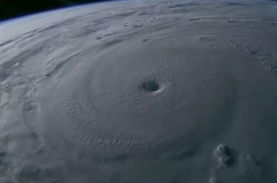
Typhoon “Bavi” is moving closer to China. According to CCTV News, the super typhoon is expected to make landfall in China around July 11 (Saturday), posing a high risk of disasters and creating a severe and complex flood prevention situation. The China Meteorological Administration issued a Blue Rainstorm Warning, a Yellow Severe Convective Weather Warning, and a Yellow Typhoon Warning at 6:00 on July 9.
Shenzhen authorities stated that satellite imagery shows Typhoon “Bavi” has a vigorous cloud system with a diameter exceeding 1,000 kilometers, making it a “giant” among typhoons. The storm is extremely intense and is expected to maintain super typhoon strength before reaching China’s coastal waters.
Shenzhen has experienced localized thundershowers in recent days. On July 9, as Typhoon “Bavi” approached the northeastern coastal waters of Taiwan Island, the monsoon over Guangdong’s coastal areas was disrupted, causing rainfall in Shenzhen to begin weakening. From July 10 to 11, under the influence of subsidence airflow from the outer periphery of “Bavi,” precipitation will decrease significantly, and high temperatures will return to Shenzhen.
On the evening of July 8, the year’s No. 9 typhoon “Bavi” (super typhoon category) entered China’s 48-hour typhoon warning line. The China Meteorological Administration activated a Level II emergency response for major meteorological disasters (typhoon, rainstorm, and severe convection). The National Marine Environmental Forecasting Center issued the first Blue Storm Surge Warning on the morning of July 9, which will later be upgraded to a Red Warning.
On the morning of July 9, the National Marine Environmental Forecasting Center issued a Red Sea Wave Warning for the southern East China Sea and waters near the Diaoyu Islands, as well as Red Nearshore Sea Wave Warnings for the coastal areas of Zhejiang and northern Fujian.
According to meteorological monitoring and forecasts, the year’s No. 9 typhoon “Bavi” is gradually moving toward the northeastern coastal waters of Taiwan Island. Under its influence, from July 10 to 11, wind speeds over the eastern Guangdong sea area and the northeastern South China Sea will increase to 7–9 on the Beaufort scale, with gusts reaching 9–11. On July 11, gusts in Meizhou and eastern Guangdong cities and counties will reach 6–9, accompanied by thundershowers.
From July 10 to 11, wind speeds over the eastern Guangdong sea area and the northeastern South China Sea will gradually increase to 7–9, with gusts of 9–11. On July 11, gusts in Meizhou and eastern Guangdong cities and counties will reach 6–9, accompanied by thundershowers.
On July 9, as Typhoon “Bavi” neared the northeastern coastal waters of Taiwan Island, the monsoon along Guangdong’s coast was cut off, and rainfall in Shenzhen began to weaken. From July 10 to 11, the city will be affected by subsidence airflow from the outer periphery of Typhoon “Bavi” over the western Pacific, leading to significantly reduced precipitation and the return of high temperatures. After “Bavi” makes landfall around July 12, the monsoon will return, and Shenzhen’s weather will become unstable again.
Shenzhen authorities remind the public that rainfall has been frequent in the city recently. Residents should remain highly vigilant against geological hazards such as landslides and ground subsidence caused by persistent heavy rainfall. Avoid staying near hazardous slopes, retaining walls, riverbanks, or similar high-risk areas.