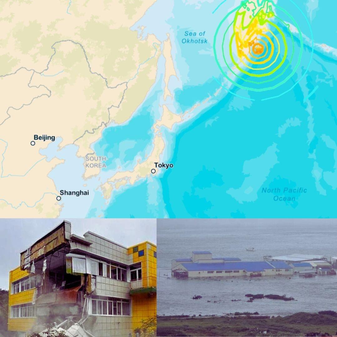
On July 30, 2025, a formidable magnitude 8.8 earthquake jolted the eastern coast of Russia’s Kamchatka Peninsula, earning its place among the strongest earthquakes ever recorded. Striking at 11:24:50 PETT (23:24:50 UTC on July 29), the quake’s epicenter was located 119 km east-southeast of Petropavlovsk-Kamchatsky, a key coastal city in Kamchatka Krai. This megathrust event, the most powerful since the 2011 Tōhoku earthquake, occurred along the Kuril–Kamchatka subduction zone, where the Pacific plate subducts beneath the North American plate at a rate of approximately 86 mm per year. The shallow depth of about 20 kilometers amplified its impact, sending shockwaves and triggering a significant tsunami across the Pacific region.
The immediate aftermath revealed moderate damage across Kamchatka Krai and Sakhalin Oblast. Local authorities, including Kamchatka Governor Vladimir Solodov, described it as “the strongest in decades,” with injuries reported and structural damage to buildings, including a kindergarten facade collapse and disrupted power grids. The ensuing tsunami brought waves up to 4 meters high to Severo-Kurilsk, flooding the port area, damaging a fish processing facility, and sweeping vessels from their moorings. Video evidence analyzed by international media showed large waves surging past coastal structures, underscoring the severity of the coastal impact.
The earthquake’s reach extended far beyond Russia, prompting a cascade of tsunami warnings across the Pacific. In Japan, over 2 million people along the eastern seaboard, particularly in Hokkaido, were ordered to evacuate, with waves peaking at 30 centimeters in Nemuro. The United States issued advisories for Alaska, Hawaii, and the west coast, where small waves of up to 1.3 meters were observed but caused no major damage. Other nations, including the Philippines, Indonesia, New Zealand, Peru, Chile, and Mexico, also activated precautionary measures, with Chile evacuating around 1.4 million people from its coastline. By the evening of July 30, most warnings were downgraded as the tsunami threat diminished, though authorities remained vigilant for aftershocks.
Geologically, this event filled a seismic gap between the 1923 and 1952 Kamchatka earthquakes, with an estimated rupture length of 600 km along the subduction zone. A foreshock of magnitude 7.4 on July 20 had hinted at heightened activity, a common precursor in the region’s tectonic history. The subsequent eruption of Klyuchevskaya Sopka, one of Kamchatka’s active volcanoes, added complexity to the disaster response, though its direct link to the earthquake remains under investigation.
The Kamchatka Peninsula’s location within the Pacific Ring of Fire, a 40,000-kilometer horseshoe-shaped zone of intense seismic and volcanic activity, explains its susceptibility to such events. Historical records, including the magnitude 9.0 earthquake of 1952 that devastated Severo-Kurilsk, reinforce the area’s long-standing risk. Despite the lack of fatalities in 2025, the combined effects of the quake, tsunami, and volcanic activity highlight the need for enhanced preparedness.
International cooperation played a crucial role in mitigating the disaster’s impact. Agencies like the U.S. Geological Survey (USGS) and the Japan Meteorological Agency provided real-time data, while global media outlets, including BBC News and Reuters, offered live updates. The rapid downgrading of tsunami warnings reflected effective communication and response, though it also underscored the unpredictable nature of such events.
In conclusion, the Kamchatka Peninsula earthquake of July 30, 2025, serves as a stark reminder of nature’s power and the importance of regional resilience. While the immediate threat has subsided, the event calls for continued investment in seismic monitoring, infrastructure reinforcement, and cross-border disaster management to safeguard vulnerable coastal communities.